Description
A coordinate system is mathematical model of the conversion between the data coordinates and a specific location on the Earth.
In order to be truly georeferenced,data needs to have a coordinate system associated to it.FME will gladly handle data without any coordinate system,but without a defined coordinate system,it will not be possible to accurately combine the dataset with those in other coordinate systems.
Coordinate system definitions are specified by a set of parameters that define this mathematical model,including the earth model (ellipsoid or datum),the units used to measure the coordinates,the projection type,and any parameters specific to the projection type.
For further information,please consider reviewing our documentation,Working with Coordinate SystemsandReprojecting Data.
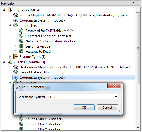
Setting a Source Coordinate System
Most formats read by FME will have a coordinate system defined on them.However,for those that have no coordinate system defined,or have an incorrect coordinate system,FME allows you to set the source coordinate system.This setting will override the coordinate system read from the data.
Coordinate systems are defined in the navigation pane of Workbench.A coordinate system can be changed by double-clicking the setting or by right-clicking and choosing the edit parameter option:
Coordinate System Gallery
You can type the name of the coordinate system directly,but it is more convenient to choose from the Coordinate System Gallery:
The Coordinate System Gallery allows you to choose a coordinate system from the list of all current CS-MAP coordinate systems,as well as any user-defined coordinate systems.The Gallery interface allows you to filter and order by name,projection datum and ellipsoid.
The last ten coordinate systems used are also available from the drop-down list in the dialog.
Setting a Destination Coordinate System
Unlike setting the Source Coordinate System,setting the Destination Coordinate System does not override the coordinate system on the data,but forces a reprojection if it is different than the coordinate system of the data.This is referred to as Implicit Reprojection,and can be a convenient,if limited,method to reproject your data.
Implicit reprojection uses the CS-MAP reprojection engine to do a horizontal reprojection only,with the default datum transformation.
When reprojecting data using the destination coordinate system setting,the reprojection happens after any processing in the workspace is complete.If you wish to perform an operation on data with disparate coordinate systems,you will need use one of the reprojector transformers to explicitly reproject to the same coordinate system before doing the operation.
Reprojector Transformers
Reprojection,including datum and ellipsoid transformation,is a complex mathematical operation.Different reprojection engines may produce slightly different results for the same reprojection.For this reason,FME has several reprojector transformers,using different reprojection engines:
- CsmapReprojectoruses the CS-MAP reprojection engine to do horizontal and vertical transformations.CS-MAP is a general reprojection engine that is included with FME and includes definitions for thousands of coordinate systems,with a large variety of projections,datums,ellipsoids and units.CS-MAP is also used by Autodesk applications.
- Reprojectoris a simpler version of the CsmapReprojector for horizontal reprojection only.It does not allow you to choose a datum transformation,or override the source data coordinate system.
- ESRIReprojectoruses the ArcGIS reprojection engine.ArcGIS must be installed and licensed on the same computer as FME for this transformer to work.It uses the ArcGIS reprojection interface to choose both the coordinate systems and datum transformations,and supports user created coordinate systems and datums transformations.
- GridInQuestReprojectoruses the GridInQuest reprojection engine to perform horizontal and vertical transformations within the United Kingdom and Ireland.
- GTransReprojectoruses the GTrans reprojection engine to perform coordinate system conversion in the Scandinavian region.
Those new to reprojection will find the Reprojector the easiest to use,while those more familiar may prefer the increased capabilities of the CsmapReprojector.
Blue Marble also offers a reprojection transformer for FME that uses their Geographic Calculator.For more information please contactBlue Marble.
Examining a Dataset's Coordinate System
If your data has a coordinate system defined,it will display in the FME Data Inspector,in the Feature Information pane:
Generally,the displayed coordinate system's name will match a define CS-MAP coordinate system,but there are a few exceptions:
- Esri Shape and Geodatabase dataset coordinate system names will be prefaced with an underscore.This is done so that the Esri coordinate system WKT read from the source can be include in the coordinate system definition,ensuring that an Esri -> Esri conversion will retain the exact coordinate system definition.
- _FME_0,_FME_1,etc.are used when the coordinate system on the source data does not match any of the CS-MAP coordinate systems.In this case,FME creates a temporary coordinate system for use within the conversion.
- KML_COORDSYS_0,SKP_COORDSYS_0 are used for 3D models stored in Google Earth and Sketchup datasets.These models are stored in a local coordinate system referenced to a latitude and longitude.FME creates a custom local coordinate system from the lat/long,allowing these datasets to be reprojected into standard coordinate systems.
If you click on the coordinate system,a dialog will pop up displaying the coordinate system parameters:
This is helpful in comparing CS-MAP coordinate systems to those on other applications.
Custom Coordinate Systems
FME comes with around 5600 pre-defined coordinate systems,but occasionally it may be necessary to add a new coordinate system.The procedure for doing so is described in the FME documentation atAdding a New Coordinate System,but we have recently added a web interface to allow you create new definition interactively,atDefine Custom Coordinate Systems.
Related articles
Creating Vertical Adjustment Grid files for use with FME
What are grid shift files and how are they managed with FME?