Introduction
Construction surveying requires a variety of measurements and knowledge of the surrounding area.Although using a single shapefile can aid in identifying where certain survey points should be within an area or along a road,it is limited in its ability to describe the natural land features.In the example below,we show how information can be extracted using both a shapefile and LAS point cloud to begin surveying for a mock road upgrade.This process is much more realistic for surveyors and engineers that may require ground data prior to any sort of construction.We will demonstrate how to buffer the road and create cross sections that are evenly spaced along a highway with the LAS point cloud data.
Creating Cross Section Slices
Downloads
The steps below outline how to use a shapefile with a point cloud to identify cross sections along a section of highway.Shapefiles are useful for understanding the geometry of a feature,but the addition of LAS data provides information about both the feature and the surrounding area with elevation data.This means in addition to locating equally spaced cross sections,you will also have a better idea of landscape that you are working in,which is extremely important when improving infrastructure.

Steps:
Isolate Area of Interest
- Add anEsri Shapefile readertothe workspace to input the road shapefile.
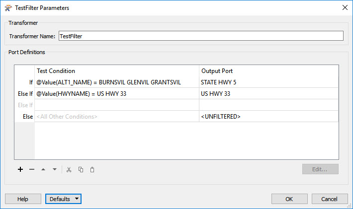
- We are interested in the section of Highway 33 that touches Highway 5.To get this portion of highway,first add aTestFilter.Double click the left cell in the first row (called "If") to fill in the parameters.Set the Left Value to "ALT1_NAME",Operator to "=",and the Right Value to "BURNSVIL GLENVIL GRANTSVIL".Double click the left cell in the second row (called "Else If") and set the Left Value to "HWYNAME",Operator to "=",and the Right Value "US HWY 33".
- Now add aSpatialFiltertransformer and connect the "STATE HWY 5" output port to the "Filter" input port.Connect the "US HWY 33" output port to the "Candidate" input port.Uncheck the "Merge Attributes" box in the SpatialFilter parameters and leave the other parameters as is.The passed sections of road are the parts of Highway 33 that touch Highway 5.
- Add aLineCombinerand connected the "Passed" outputs from the SpatialFilter to the input port.Set Break Across Attribute Values to "No" and Accumulation Mode to "Drop Incoming Attributes".This creates a single line feature which will simplify further processing.
Create and Buffer Cross Sections - Now connect the "Line" output to the input port of the custom transformer calledCrossSectionsCreator.This custom transformer will output lines that are perpendicular to the highway at equal intervals of 500 map units (excluding the last cross section line which is drawn at the end of the highway).This value is pre-set in the custom transformer,but can be changed by editing the custom transformer.More information on how to do this is provided below.
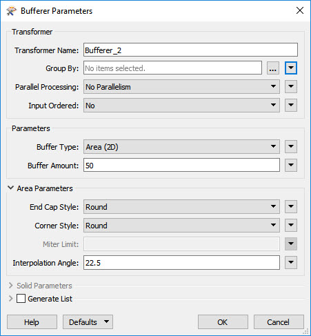
- We are now interested in buffering the cross sections.Add aBuffererand connect the "Output" cross sections to the input port.Change the parameters so that Buffer Amount is set to 50 and both the End Cap Style and Corner Style are set to "Round".
Retrieve LAS Ground Points - We will now add our LAS data set to the workspace using an ASPRS Reader with default parameters.Do not connect it to the previously added transformers.
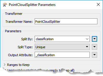
- Add aPointCloudSplitterand connect the reader to it.Set the parameters so that the point cloud is Split By "classification",the Split Type is "Unique" and the Output Attribute is "_classifcation".
- Connect the "Split" points to the custom transformer calledPointCloudLASClassifier.
Clip Point Cloud to Highway - Before further manipulating the point cloud,first connect the "Line" output from the LineCombiner to a Bufferer.Change the Buffer Amount to 200 and set both the End Cap Style and Corner Style to "Round".
- Add a限幅器transformer to the 亚搏在线workflow.Connect the "Ground" output from the PointCloudLASClassifier to the "Clippee" input.Connect the "Buffered" line to the "Clipper" input.
- Now add aPointCloudCombinertransformer and connect the "Inside" Clipper points to the input port.
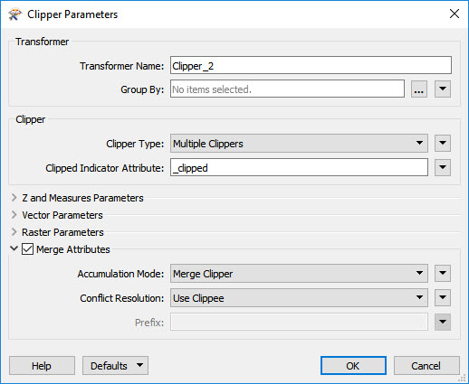
Clip Point Cloud to Cross Sections - Add a second Clipper and connect the "Output" combined points to the "Clippee" input port.Check the "Merge Attributes" box in the parameters.Connect the "Buffered" cross sections to the "Clipper" input.
- Connect the "Inside" outputs from the Clipper to aCountertransformer.
- The output of the Counter is the final product and can be viewed using an Inspector.Alternatively the output can be written using an ASPRS Writer,Pointools POD,or Bentley MicroStation Design (V8) for viewing in MicroStation.


The images below show the resulting output point cloud cross sections in 2D and 3D along the section of highway that we were interested in.In image a.you can see that the cross sections were accurately drawn to be perpendicular at each 500 unit interval so each cross section is on a slightly different angle than the others.In image b.you can see that by using a 3D point cloud to represent each cross section we get a better sense of what the highway and surrounding area look like in reality versus using 2D shapefiles.
a. b.
b.
Creating Cross-Section Profiles
Downloads
Two-dimensional profiles of cross sections can help to emphasize the natural landscape in the area that you will be working in.With a highway improvement,this can help with understanding what kind of work will be required for widening a highway or which locations will require more or less analysis prior to construction.For example,if you can see in a profile that the cross section is quite steep,you will know that this location may require further analysis to ensure that the ground is stable.The steps below use the previously created cross-section slices to create profiles.This example will work off the previous workspace by adding more transformers following Step 14 which ended with a Counter transformer.

Steps:
Rotate Slices and Add Attributes
- Connect the Counter Output to aBoundsExtractor.The parameters can remain as the defaults.This transformer will add minimum and maximum x,y,and z coordinate attributes to the point cloud slices.
- Now we will connect the BoundsExtractor outputs to aRotatortransformer.Use the drop down arrows to the right of the parameters to set each to an Attribute Value.Set Rotation Angle (degrees) to "acAzimuth",X Origin (Vector Only) to "_xmin" and Y Origin (Vector Only) to "_ymin".This will rotate each slice so that they are all parallel to each other.
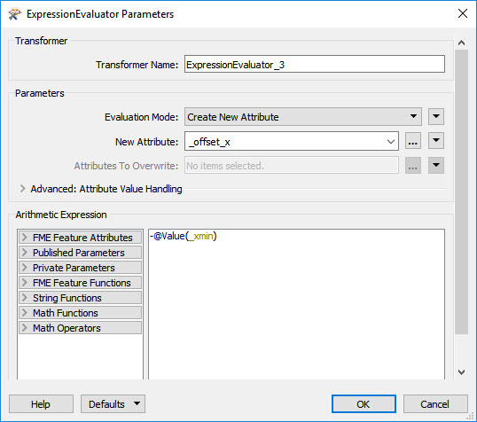
- Add anExpressionEvaluatorand connect the "Rotated" outputs to the input port.In the parameters set New Attribute to "_offset_x".Fill in the Arithmetic Expression box with "-@Value(_xmin)".
- Add another ExpressionEvaluator connected to the last.This transformer will focus on the y coordinates.Set the New Attribute to "_offset_y" and fill the Arithmetic Expression box with "-@Value(_ymin)".
Align the Slice Around the Same Origin - Connect anOffsettertransformer to the last ExpressionEvaluator.Change the parameters so that X Offset is set to "_offset_x" and Y Offset is set to "_offset_y".The Z Offset should remain as 0.This transformer will move each slice so that the bottom left point of the original bounds around each slice (not the bottom left point of the actual point cloud slice) align at point 0,0.The slices themselves will now overlap in the same general area.
- To create the profiles we will need the points in the point cloud to be read as feature points instead.Add aPointCloudCoercerand connect the Offseter to the input port.Set the Output Geometry in the Parameters to "Individual Points".
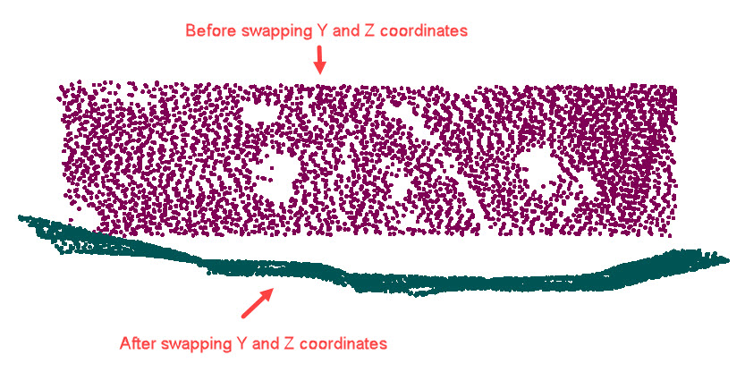
Create Profiles - Now we will use aCoordinateSwappertransformer.After connecting the previous outputs to the input port,change the Swap Type in the parameters to "Y< - >Z".Because we are moving from a 3D X,Y,Z coordinate system to a 2D X,Y coordinate system to display the profiles,we want to essentially flip the viewing angle of the slice so that we are looking at the curve of the profile.This is what this transformer will do.
- Connect a2DForcertransformer to the output of the CoordinateSwapper to remove the Z values of each feature.
- Add aScaler.Change the Y Scale Factor in the parameters to 3.This will exaggerate the profile which will help distinguish differences between the various profiles.
- Connect aCoordinateExtractorand change the mode to "Specify Coordinate".Set the Default Z Value to -9999 and keep the other parameters set to their defaults.
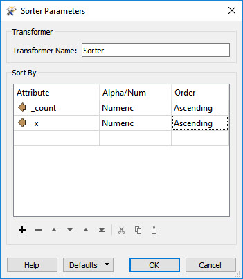
Finalize Profiles - We will now use aSortertransformer to sort the points by count (each count represents one cross section) and x value.This will aid in drawing the profiles neatly.In the first row set Attribute to "_count",Alpha/Num to "Numeric" and Order to "Ascending".In a second row set Attribute to "_x",Alpha/Num to "Numeric" and Order to "Ascending".
- Finally add aLineBuilderconnected to the "Sorted" outputs.In the parameters set Connection Break Attributes to "_count".
- Add an Inspector connected to the "Line" output of the LineBuilder.Also connect the "Sorted" points from the Sorter.By connecting both transformer to an inspector we will be able to see both the points and the newly built lines.The result should look like the image below.


Data Attribution
- The data used here originates from open data made available by theWest Virginia GIS Technical Center.
Hi,
this seems a pretty fine 亚搏在线workflow.I'm interested in the
"LIDAR_Slices.fmwt"...could you attach it please?
Greetings from Germany
Thorsten
Hi@schefthI have attached the template to this article (sorry it was missing).
Hi,
the template works really fine and does exactly what I need
for my project.
But I still have a question: As an extra process,you created
profiles along the cross-sections.I also done this by using a
very small buffer size (Buffer_2) of 1cm and after that I created
a single line with the "PointConnector" and the "Generalizer".
This works good,but there is still this maximum expansion of 1cm
in the Y-Direction.How did you realize the 'flat' profiles?Did you
project the points of the slice to an plain which is part of
the cross-section-line (at right angle to the middle-line
of the road)?How did you realize this?
Thanks
Thorsten
Hi Thorsten,
I am attaching a workspace that contains the part where I create the profiles (which,as I aid in the article,was excluded from the original download).It was 5 years ago when I created the workspace,but if I recall correctly,the idea was to take a "thick" slice,swap Y and Z (CoordinateSwapper),and then eliminate z (2DForcer).As result,all points line up on a single line and can be sorted (Sorter) and connected (PointConnector).
I hope this answers your question.If you have more questions,please let me know.